Last official estimated population of Shoshone County was 12,718 (year 2014)[1]. This was 0.004% of total US population and 0.8% of total Idaho state population. Area of Shoshone County is 2,635.2 mi² (=6825.2 km²), in this year population density was 4.83 p/mi². If population growth rate would be same as in period 2010-2014 (-0.09%/yr), Shoshone County population in 2026 would be 12,578 [0].
Historical population of Shoshone County for period 1870-2014 [1] , [2] , [3]:
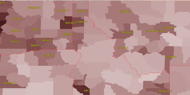
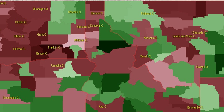
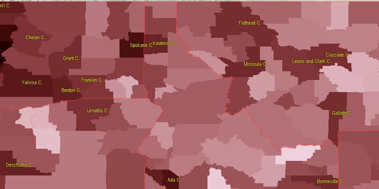
Estimated population for 2014[1]. Population density is in p./sq.mi [4]. Changes are for period 2010-2015. Value is %/year. Boundary lines are approx. 2012 [5]. Click on flag to hide it.
Population • Density • Changes • Legends • Position

[1870-1880] -4.22 %/yr
[1880-1890] +27.64 %/yr
[1890-1900] +8.3 %/yr
[1900-1910] +1.57 %/yr
[1910-1920] +0.2 %/yr
[1920-1930] +2.95 %/yr
[1930-1940] +1.08 %/yr
[1940-1950] +0.72 %/yr
[1950-1960] -0.88 %/yr
[1960-1970] -0.57 %/yr
[1970-1980] -0.25 %/yr
[1980-1990] -3.17 %/yr
[1990-2000] -0.12 %/yr
[2000-2005] -1.27 %/yr
[2005-2010] -0.23 %/yr
[2010-2014] -0.09 %/yr
Looking for settlements in Shoshone County? Visit this page: Settlements in Shoshone County, ID
Population of Shoshone County by age groups male (M) and female (F)[1b]
| Age Gr. | (M) | (F) | Total |
| 0 to 4 | 342 | 298 | 640 |
| 5 to 9 | 333 | 304 | 637 |
| 10 to 14 | 363 | 353 | 716 |
| 15 to 19 | 364 | 336 | 700 |
| 20 to 24 | 329 | 294 | 623 |
| 25 to 29 | 315 | 298 | 613 |
| 30 to 34 | 313 | 294 | 607 |
| 35 to 39 | 309 | 308 | 617 |
| 40 to 44 | 348 | 348 | 696 |
| 45 to 49 | 394 | 382 | 776 |
| 50 to 54 | 515 | 453 | 968 |
| 55 to 59 | 499 | 576 | 1,075 |
| 60 to 64 | 542 | 488 | 1,030 |
| 65 to 69 | 478 | 460 | 938 |
| 70 to 74 | 337 | 312 | 649 |
| 75 to 79 | 230 | 275 | 505 |
| 80 to 84 | 144 | 187 | 331 |
| 85+ | 99 | 170 | 269 |
Shoshone County resident population estimates by Sex, Race, and Hispanic Origin[1b]. For full list of abbrevations see: population.us/about page.
| Race | Male | Female | Total |
| WAC | 6073 | 5963 | 12,036 |
| NH | 6015 | 5949 | 11,964 |
| WA | 5937 | 5823 | 11,760 |
| NHWAC | 5855 | 5798 | 11,653 |
| NHWA | 5734 | 5672 | 11,406 |
| H | 239 | 187 | 426 |
| IAC | 212 | 199 | 411 |
| NHIAC | 197 | 187 | 384 |
| HWAC | 218 | 165 | 383 |
| HWA | 203 | 151 | 354 |
| TOM | 141 | 141 | 282 |
| NHTOM | 126 | 127 | 253 |
| IA | 116 | 101 | 217 |
| NHIA | 107 | 98 | 205 |
| AAC | 51 | 65 | 116 |
| NHAAC | 47 | 57 | 104 |
| BAC | 46 | 34 | 80 |
| AA | 26 | 42 | 68 |
| NHBAC | 37 | 29 | 66 |
| NHAA | 23 | 38 | 61 |
| BA | 26 | 17 | 43 |
| NAC | 20 | 17 | 37 |
| NHBA | 22 | 13 | 35 |
| HTOM | 15 | 14 | 29 |
| HIAC | 15 | 12 | 27 |
| NA | 8 | 12 | 20 |
| HNAC | 8 | 11 | 19 |
| NHNAC | 12 | 6 | 18 |
| HNA | 5 | 11 | 16 |
| HBAC | 9 | 5 | 14 |
| HIA | 9 | 3 | 12 |
| HAAC | 4 | 8 | 12 |
| HBA | 4 | 4 | 8 |
| HAA | 3 | 4 | 7 |
| NHNA | 3 | 1 | 4 |
• Spokane County population
73.3 mi,  284°
284°
• Kootenai County
44.1 mi,  301°
301°
• Bonner County
75.8 mi,  332°
332°
• Nez Perce County
81.4 mi,  210°
210°
• Latah County
54 mi,  227°
227°
• Sanders County
43.3 mi,  49°
49°
• Benewah County
36.2 mi,  255°
255°
• Clearwater County
47.9 mi,  166°
166°
• Mineral County
40.7 mi,  109°
109°
• Lewis County
80.9 mi,  198°
198°
[0] Calculated by population.us from last known population growth rate, not official data.
[1] County population - 2014, archived from the original, retrieved 02/23/2016
[1b] Annual County Resident Population Estimates by Age, Sex, Race, and Hispanic Origin, (used only data for 2014) archived from the original, retrieved 02/23/2016
[2] County population - 2000-2010, archived from the original, retrieved 02/23/2016
[3] Population of States and Counties of the United States: 1790 to 1992, PDF, 15 Mb, census.gov, retrieved 02/23/2016
[4] County area, latitude longitude data, retrieved 02/23/2016
[5] County boundaries, CSV files on boundaries.us, retrived 03/18/2016
Page generated in 0.013 seconds© 2016 population.us | Terms of use | Contact