Last official estimated population of Curry County was 22,364 (year 2014)[1]. This was 0.007% of total US population and 0.6% of total Oregon state population. Area of Curry County is 1,988.4 mi² (=5149.8 km²), in this year population density was 11.25 p/mi². If population growth rate would be same as in period 2010-2014 (0%/yr), Curry County population in 2026 would be 22,364 [0].
Historical population of Curry County for period 1860-2014 [1] , [2] , [3]:
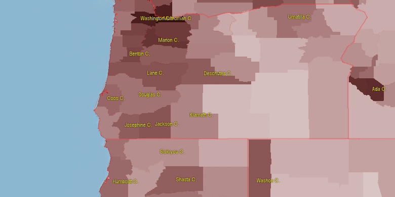
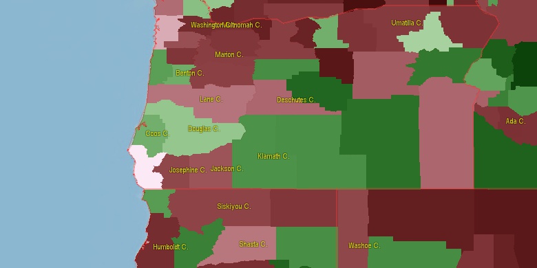
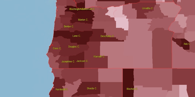
Estimated population for 2014[1]. Population density is in p./sq.mi [4]. Changes are for period 2010-2015. Value is %/year. Boundary lines are approx. 2012 [5]. Click on flag to hide it.
Population • Density • Changes • Legends • Position

[1860-1870] +2.52 %/yr
[1870-1880] +9.13 %/yr
[1880-1890] +3.53 %/yr
[1890-1900] +0.89 %/yr
[1900-1910] +0.9 %/yr
[1910-1920] +4 %/yr
[1920-1930] +0.74 %/yr
[1930-1940] +2.82 %/yr
[1940-1950] +3.47 %/yr
[1950-1960] +8.74 %/yr
[1960-1970] -0.72 %/yr
[1970-1980] +2.71 %/yr
[1980-1990] +1.3 %/yr
[1990-2000] +0.9 %/yr
[2000-2005] +1.47 %/yr
[2005-2010] -0.34 %/yr
[2010-2014] 0 %/yr
Looking for settlements in Curry County? Visit this page: Settlements in Curry County, OR
Population of Curry County by age groups male (M) and female (F)[1b]
| Age Gr. | (M) | (F) | Total |
| 0 to 4 | 496 | 460 | 956 |
| 5 to 9 | 452 | 402 | 854 |
| 10 to 14 | 511 | 474 | 985 |
| 15 to 19 | 584 | 454 | 1,038 |
| 20 to 24 | 463 | 412 | 875 |
| 25 to 29 | 437 | 439 | 876 |
| 30 to 34 | 461 | 441 | 902 |
| 35 to 39 | 441 | 461 | 902 |
| 40 to 44 | 476 | 511 | 987 |
| 45 to 49 | 576 | 616 | 1,192 |
| 50 to 54 | 764 | 826 | 1,590 |
| 55 to 59 | 879 | 1040 | 1,919 |
| 60 to 64 | 1109 | 1161 | 2,270 |
| 65 to 69 | 1095 | 1144 | 2,239 |
| 70 to 74 | 900 | 888 | 1,788 |
| 75 to 79 | 635 | 662 | 1,297 |
| 80 to 84 | 400 | 435 | 835 |
| 85+ | 335 | 495 | 830 |
Curry County resident population estimates by Sex, Race, and Hispanic Origin[1b]. For full list of abbrevations see: population.us/about page.
| Race | Male | Female | Total |
| WAC | 10587 | 10866 | 21,453 |
| NH | 10247 | 10627 | 20,874 |
| WA | 10237 | 10476 | 20,713 |
| NHWAC | 9872 | 10217 | 20,089 |
| NHWA | 9572 | 9873 | 19,445 |
| H | 767 | 694 | 1,461 |
| HWAC | 715 | 649 | 1,364 |
| HWA | 665 | 603 | 1,268 |
| IAC | 524 | 553 | 1,077 |
| NHIAC | 454 | 489 | 943 |
| TOM | 367 | 408 | 775 |
| NHTOM | 315 | 361 | 676 |
| IA | 263 | 254 | 517 |
| NHIA | 227 | 219 | 446 |
| AAC | 128 | 189 | 317 |
| NHAAC | 115 | 180 | 295 |
| AA | 75 | 140 | 215 |
| BAC | 120 | 92 | 212 |
| NHAA | 66 | 137 | 203 |
| NHBAC | 100 | 77 | 177 |
| HIAC | 70 | 64 | 134 |
| HTOM | 52 | 47 | 99 |
| BA | 60 | 32 | 92 |
| NHBA | 56 | 26 | 82 |
| NAC | 35 | 38 | 73 |
| HIA | 36 | 35 | 71 |
| NHNAC | 30 | 31 | 61 |
| HBAC | 20 | 15 | 35 |
| NA | 12 | 11 | 23 |
| HAAC | 13 | 9 | 22 |
| NHNA | 11 | 11 | 22 |
| HAA | 9 | 3 | 12 |
| HNAC | 5 | 7 | 12 |
| HBA | 4 | 6 | 10 |
| HNA | 1 | 0 | 1 |
• Lane County population
120.7 mi,  33°
33°
• Jackson County
78.4 mi,  92°
92°
• Humboldt County
122.5 mi,  173°
173°
• Douglas County
77.9 mi,  43°
43°
• Josephine County
33.1 mi,  99°
99°
• Klamath County
131.3 mi,  83°
83°
• Coos County
50 mi,  6°
6°
• Siskiyou County
105.3 mi,  125°
125°
• Del Norte County
50.9 mi, 166°
• Trinity County
137.8 mi,  155°
155°
[0] Calculated by population.us from last known population growth rate, not official data.
[1] County population - 2014, archived from the original, retrieved 02/23/2016
[1b] Annual County Resident Population Estimates by Age, Sex, Race, and Hispanic Origin, (used only data for 2014) archived from the original, retrieved 02/23/2016
[2] County population - 2000-2010, archived from the original, retrieved 02/23/2016
[3] Population of States and Counties of the United States: 1790 to 1992, PDF, 15 Mb, census.gov, retrieved 02/23/2016
[4] County area, latitude longitude data, retrieved 02/23/2016
[5] County boundaries, CSV files on boundaries.us, retrived 03/18/2016
*Benton Oregon Notes
Page generated in 0.014 seconds© 2016 population.us | Terms of use | Contact