Last official estimated population of Grand Isle County was 6,958 (year 2014)[1]. This was 0.002% of total US population and 1.1% of total Vermont state population. Area of Grand Isle County is 194.7 mi² (=504.2 km²), in this year population density was 35.74 p/mi². If population growth rate would be same as in period 2010-2014 (-0.04%/yr), Grand Isle County population in 2026 would be 6,922 [0].
Historical population of Grand Isle County for period 1810-2014 [1] , [2] , [3]:
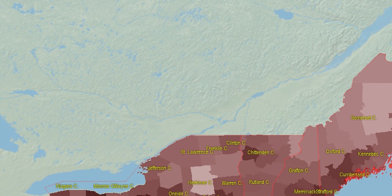
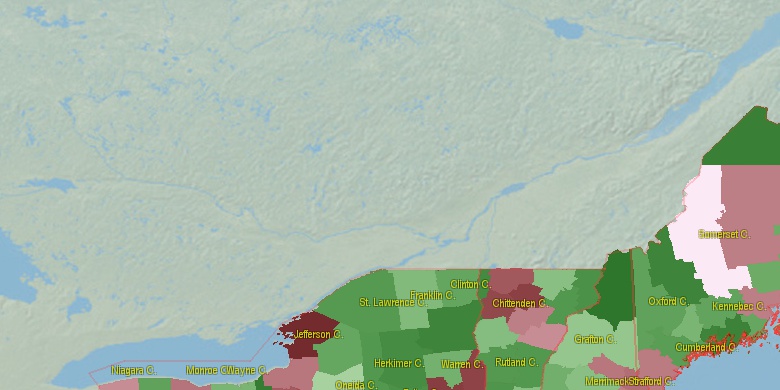
Estimated population for 2014[1]. Population density is in p./sq.mi [4]. Changes are for period 2010-2015. Value is %/year. Boundary lines are approx. 2012 [5]. Click on flag to hide it.
Population • Density • Changes • Legends • Position

[1810-1820] +0.24 %/yr
[1820-1830] +0.47 %/yr
[1830-1840] +0.49 %/yr
[1840-1850] +0.66 %/yr
[1850-1860] +0.31 %/yr
[1860-1870] -0.46 %/yr
[1870-1880] +0.1 %/yr
[1880-1890] -0.7 %/yr
[1890-1900] +1.5 %/yr
[1900-1910] -1.69 %/yr
[1910-1920] +0.06 %/yr
[1920-1930] +0.41 %/yr
[1930-1940] -0.37 %/yr
[1940-1950] -1.09 %/yr
[1950-1960] -1.5 %/yr
[1960-1970] +2.02 %/yr
[1970-1980] +2.58 %/yr
[1980-1990] +1.43 %/yr
[1990-2000] +2.62 %/yr
[2000-2005] +1.13 %/yr
[2005-2010] -0.87 %/yr
[2010-2014] -0.04 %/yr
Looking for settlements in Grand Isle County? Visit this page: Settlements in Grand Isle County, VT
Population of Grand Isle County by age groups male (M) and female (F)[1b]
| Age Gr. | (M) | (F) | Total |
| 0 to 4 | 145 | 180 | 325 |
| 5 to 9 | 162 | 184 | 346 |
| 10 to 14 | 202 | 185 | 387 |
| 15 to 19 | 209 | 190 | 399 |
| 20 to 24 | 179 | 170 | 349 |
| 25 to 29 | 186 | 158 | 344 |
| 30 to 34 | 167 | 174 | 341 |
| 35 to 39 | 182 | 196 | 378 |
| 40 to 44 | 195 | 210 | 405 |
| 45 to 49 | 244 | 264 | 508 |
| 50 to 54 | 293 | 328 | 621 |
| 55 to 59 | 355 | 322 | 677 |
| 60 to 64 | 341 | 319 | 660 |
| 65 to 69 | 283 | 255 | 538 |
| 70 to 74 | 173 | 151 | 324 |
| 75 to 79 | 91 | 101 | 192 |
| 80 to 84 | 55 | 65 | 120 |
| 85+ | 23 | 57 | 80 |
Grand Isle County resident population estimates by Sex, Race, and Hispanic Origin[1b]. For full list of abbrevations see: population.us/about page.
| Race | Male | Female | Total |
| NH | 3409 | 3462 | 6,871 |
| WAC | 3403 | 3420 | 6,823 |
| NHWAC | 3334 | 3379 | 6,713 |
| WA | 3308 | 3322 | 6,630 |
| NHWA | 3247 | 3283 | 6,530 |
| IAC | 120 | 106 | 226 |
| NHIAC | 111 | 102 | 213 |
| TOM | 98 | 99 | 197 |
| NHTOM | 90 | 96 | 186 |
| H | 76 | 47 | 123 |
| HWAC | 69 | 41 | 110 |
| HWA | 61 | 39 | 100 |
| BAC | 45 | 45 | 90 |
| IA | 46 | 42 | 88 |
| NHIA | 41 | 40 | 81 |
| NHBAC | 38 | 40 | 78 |
| BA | 25 | 21 | 46 |
| NHAAC | 15 | 27 | 42 |
| AAC | 15 | 27 | 42 |
| NHBA | 23 | 18 | 41 |
| AA | 7 | 18 | 25 |
| NHAA | 7 | 18 | 25 |
| NHNAC | 5 | 14 | 19 |
| NAC | 5 | 14 | 19 |
| HIAC | 9 | 4 | 13 |
| HBAC | 7 | 5 | 12 |
| HTOM | 8 | 3 | 11 |
| NA | 1 | 7 | 8 |
| NHNA | 1 | 7 | 8 |
| HIA | 5 | 2 | 7 |
| HBA | 2 | 3 | 5 |
| HNAC | 0 | 0 | 0 |
| HAAC | 0 | 0 | 0 |
| HNA | 0 | 0 | 0 |
| HAA | 0 | 0 | 0 |
• Chittenden County population
26 mi,  154°
154°
• Clinton County
20.1 mi,  260°
260°
• Washington County
49.8 mi,  136°
136°
• Franklin County
51.6 mi,  253°
253°
• Franklin County
19.6 mi,  78°
78°
• Essex County
53.3 mi,  206°
206°
• Addison County
53.8 mi,  171°
171°
• Caledonia County
62.8 mi,  111°
111°
• Orleans County
51.5 mi,  87°
87°
• Lamoille County
35.3 mi, 112°
[0] Calculated by population.us from last known population growth rate, not official data.
[1] County population - 2014, archived from the original, retrieved 02/23/2016
[1b] Annual County Resident Population Estimates by Age, Sex, Race, and Hispanic Origin, (used only data for 2014) archived from the original, retrieved 02/23/2016
[2] County population - 2000-2010, archived from the original, retrieved 02/23/2016
[3] Population of States and Counties of the United States: 1790 to 1992, PDF, 15 Mb, census.gov, retrieved 02/23/2016
[4] County area, latitude longitude data, retrieved 02/23/2016
[5] County boundaries, CSV files on boundaries.us, retrived 03/18/2016
See note 2 Vermont Notes
Page generated in 0.021 seconds© 2016 population.us | Terms of use | Contact