Last official estimated population of Yukon-Koyukuk Census Area was 5,589 (year 2014)[1]. This was 0.002% of total US population and 0.8% of total Alaska state population. Area of Yukon-Koyukuk Census Area is 147,791.9 mi² (=382779.5 km²), in this year population density was 0.04 p/mi². If population growth rate would be same as in period 2010-2014 (+0%/yr), Yukon-Koyukuk Census Area population in 2026 would be 5,592 [0].
Historical population of Yukon-Koyukuk Census Area for period 1960-2014 [1] , [2] , [3]:
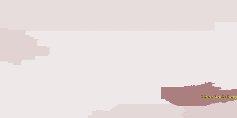
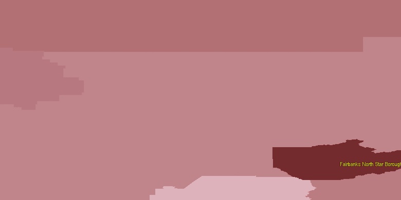
Estimated population for 2014[1]. Population density is in p./sq.mi [4]. Changes are for period 2010-2015. Value is %/year. Boundary lines are approx. 2012 [5]. Click on flag to hide it.
Population • Density • Changes • Legends • Position

[1960-1970] +1.49 %/yr
[1970-1980] +5.18 %/yr
[1980-1990] -1.46 %/yr
[1990-2000] -0.43 %/yr
[2000-2005] -1.62 %/yr
[2005-2010] -1.41 %/yr
[2010-2014] +0 %/yr
Looking for settlements in Yukon-Koyukuk Census Area? Visit this page: Settlements in Yukon-Koyukuk Census Area, AK
Population of Yukon-Koyukuk Census Area by age groups male (M) and female (F)[1b]
| Age Gr. | (M) | (F) | Total |
| 0 to 4 | 218 | 242 | 460 |
| 5 to 9 | 227 | 185 | 412 |
| 10 to 14 | 202 | 193 | 395 |
| 15 to 19 | 212 | 201 | 413 |
| 20 to 24 | 213 | 154 | 367 |
| 25 to 29 | 195 | 169 | 364 |
| 30 to 34 | 202 | 154 | 356 |
| 35 to 39 | 163 | 131 | 294 |
| 40 to 44 | 120 | 125 | 245 |
| 45 to 49 | 163 | 145 | 308 |
| 50 to 54 | 192 | 175 | 367 |
| 55 to 59 | 253 | 193 | 446 |
| 60 to 64 | 217 | 167 | 384 |
| 65 to 69 | 142 | 124 | 266 |
| 70 to 74 | 107 | 76 | 183 |
| 75 to 79 | 62 | 51 | 113 |
| 80 to 84 | 42 | 60 | 102 |
| 85+ | 46 | 26 | 72 |
Yukon-Koyukuk Census Area resident population estimates by Sex, Race, and Hispanic Origin[1b]. For full list of abbrevations see: population.us/about page.
| Race | Male | Female | Total |
| NH | 2919 | 2517 | 5,436 |
| IAC | 2194 | 1949 | 4,143 |
| NHIAC | 2176 | 1928 | 4,104 |
| IA | 2073 | 1851 | 3,924 |
| NHIA | 2057 | 1830 | 3,887 |
| WAC | 871 | 676 | 1,547 |
| NHWAC | 831 | 643 | 1,474 |
| WA | 719 | 568 | 1,287 |
| NHWA | 683 | 535 | 1,218 |
| TOM | 157 | 123 | 280 |
| NHTOM | 153 | 123 | 276 |
| H | 57 | 54 | 111 |
| HWAC | 40 | 33 | 73 |
| HWA | 36 | 33 | 69 |
| BAC | 35 | 34 | 69 |
| NHBAC | 32 | 34 | 66 |
| NHAAC | 25 | 31 | 56 |
| AAC | 25 | 31 | 56 |
| HIAC | 18 | 21 | 39 |
| HIA | 16 | 21 | 37 |
| BA | 17 | 15 | 32 |
| NHBA | 16 | 15 | 31 |
| AA | 3 | 13 | 16 |
| NHAA | 3 | 13 | 16 |
| NAC | 9 | 6 | 15 |
| NHNAC | 9 | 6 | 15 |
| NA | 7 | 1 | 8 |
| NHNA | 7 | 1 | 8 |
| HTOM | 4 | 0 | 4 |
| HBAC | 3 | 0 | 3 |
| HBA | 1 | 0 | 1 |
| HNAC | 0 | 0 | 0 |
| HAA | 0 | 0 | 0 |
| HNA | 0 | 0 | 0 |
| HAAC | 0 | 0 | 0 |
• Anchorage Municipality population
298.8 mi,  166°
166°
• Fairbanks North Star Borough
152.6 mi,  108°
108°
• Matanuska-Susitna Borough
222.1 mi,  164°
164°
• Kenai Peninsula Borough
346.9 mi,  183°
183°
• Valdez-Cordova Census Area
344 mi,  143°
143°
• Nome Census Area
368.8 mi,  263°
263°
• North Slope Borough
285.9 mi,  349°
349°
• Northwest Arctic Borough
260.7 mi,  295°
295°
• Southeast Fairbanks Census Area
268.4 mi, 112°
• Denali Borough
125.8 mi, 158°
[0] Calculated by population.us from last known population growth rate, not official data.
[1] County population - 2014, archived from the original, retrieved 02/23/2016
[1b] Annual County Resident Population Estimates by Age, Sex, Race, and Hispanic Origin, (used only data for 2014) archived from the original, retrieved 02/23/2016
[2] County population - 2000-2010, archived from the original, retrieved 02/23/2016
[3] Population of States and Counties of the United States: 1790 to 1992, PDF, 15 Mb, census.gov, retrieved 02/23/2016
[4] County area, latitude longitude data, retrieved 02/23/2016
[5] County boundaries, CSV files on boundaries.us, retrived 03/18/2016
1970 pop. in 1980 area: 7,039 Alaska Notes
Page generated in 0.017 seconds© 2016 population.us | Terms of use | Contact